1.4. GUI for Interactive Maps
Learning Objectives
You will be able...
- ...to name at least three functional groups with their subgroups.
- ...to assign any function of any interactive map to their corresponding functional group or sub-group.
- ...to list the four rules for item organisation on the screen.
Introduction
Since the main topic of this module is multimedia cartography, we here concentrate on the GUI of interactive maps. We already talked about User Interface and Graphical User Interface in general. We now want to introduce tools or items that are typical for interactive maps.
|
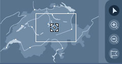
Each tool of an interactive map can be assigned to a functional group. This means that tools with similar functions can be classified into groups. For example zoom in, zoom out, and pan can be pooled within the functional group "Navigational Functions". Precisely, we talk about spatial navigation what is a sub-group of navigational functions in general. You now see that we distinguish between the main functional groups and further divide them into sub-groups. |
 Spatial Navigation in Atlas of Switzerland 2 (Atlas of Switzerland 2004) Spatial Navigation in Atlas of Switzerland 2 (Atlas of Switzerland 2004) |
Considering the classification of the tools, the tools must be arranged on the screen. There exist a few content organisation rules that we present you in this chapter. Further on, we picked a few interactive maps and analysed them according to our tool classification and their arrangement on the screen. We do not give you advices how to arrange an interactive map best. Depending on the features, the end users, the message of the map, etc. you have to define your own content organisation. The presented examples show you a few possible content arrangements of an interactive map.
