1.5. Summary
The Open Geospatial Consortium (OGC) is an international consortium that develops publicly available specifications that support interoperable solutions that "geo-enable" the Web. That means when these specifications are implemented by two different software engineers working independently, the resulting components work together without further debugging.
There are a lof of specifications but the most important ones are the Geography Markup Language (GML), Web Map Service (WMS) and Web Feature Service (WFS):
-
GML is an XML encoding for the transport and storage of geographic information, including both the geometry and properties of geographic features (Reichhardt 2003).
-
WMS is a standard that provides a standard interface for querying and accessing map layers from a mapping server. GetMap and GetCapabilities are the mandatory operations that are defined by WMS.
-
WFS is an interface allowing requests for geographical features across the web using platform-independent calls (the result is a GML-file) (Wikipedia). GetCapabilities, DescribeFeatureType, and GetFeature are the mandatory operations that are defined by WFS.
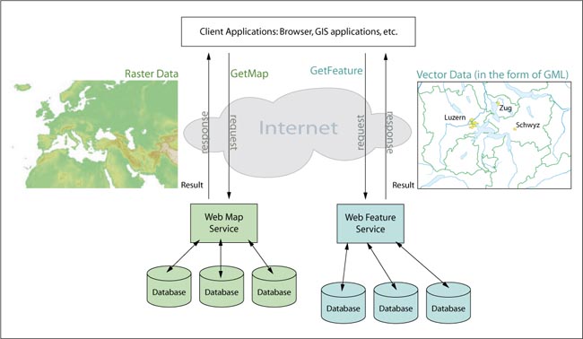
The following graphic shows the difference of the results of a GetMap (WMS) and a GetFeature (WFS) request.
 Web Map Service versus Web Feature Service
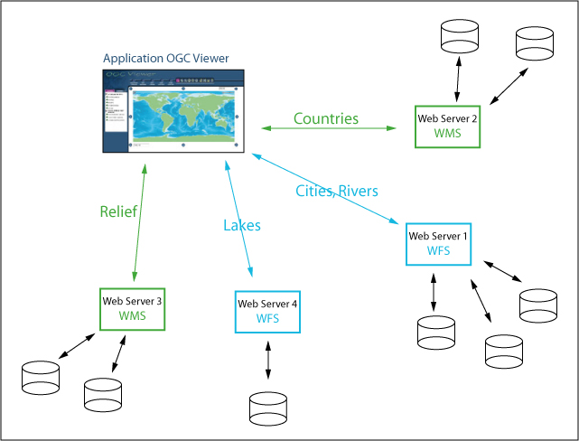
In this lesson we presented you the services separately. We
either talked about WMS or WFS. But normally, these and other services are combined
and
the data is loaded from an arbitrary number of different web servers. For example:
many
applications load the raster data from one web server that supports WMS and the
features
are loaded from another web server that supports WFS.
The following picture
demonstrates the combination of different services:
 Combination of WMS and WFS