1.5.2. Chunking a Route
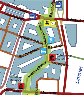
In this activity you will think about the problem of chunking in more detail. To do this you will need to printout a copy of this pdf file showing a map (loosely based) on Zurich. You will use this map to draw on decision points where a turn type instruction must be given.
When the route description is first computed by the spatial model, every road link and junction node will be included. If this is used as it is the instructions can become very tiresome. For example every time the driver passes by a side street and instruction such as "Continue straight ahead" would be given. The aim of chunking is to limit the decision point instructions to only those those places where the driver must stop and make a turn. There are three main situations where this is important.
- White lines - this is to avoid the type of situation described above. An instruction only needs to be given when the driver will come to a stop and make a turn. You can think of these points as where there is a white line painted across the road indicating the driver must stop. Usually these points are determined by the relative priority of the road but this information is often not available explicitly in a database, so instead you need to think of rules that account for this situation. For example when the class or the name of the road changes.
- Concatenated instructions - Sometimes multiple turns will occur very quickly one after the other. In these situations the driver cannot hear the whole of one instruction before the next one must be given. To solve this problem instructions must be concatnated. For example "Turn left ... then immediately turn right ...".
- Slip roads - slip roads are very short segments of connecting roads that transit from one road to another. For example these occur when two lanes are split at a T-junction or when leaving a Motorway (Autobahn). In most cases instructions on how to navigate these roads can be omitted entirely and only the turning relationship between the two main roads considered.
On the map you have printed out mark the points where instructions need to be given and concatenated. Write down the rules you used to decide on why the locations were decision points.

