1.3.2. Adaption
How do services respond to context?
Systems that can dynamically change their behaviour because of context have been termed variously; reactive, responsive, situated, context-sensitive and environment directed (Abowd et al. 1999). However, the term adaptive has become the most commonly used in mobile cartography (Reichenbacher 2004).
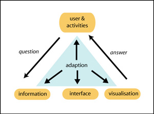
Adaption can take place at four different levels (Reichenbacher 2003):
- Information level: the content of the information is adapted. Examples include filtering information by proximity to a user or changing the level of detail of information according to tasks (Timpf et al. 2003).
- Technology level: Information is encoded to suit different device characteristics (e.g. display size and resolution, network and positioning availability). For example using auditory driving instructions for users with mobile phones or maps for users with PDAs.
- User interface level: the user interface is adapted. For example automatically panning and re-orientating a map as the user moves about.
- Presentation level: the visualisation of the information is adapted. For example restaurants that are more relevant to a user's preferences in price and taste are shown with more crisp icons and those less relevant use more opaque ones.
 Levels of adaption for mobile technologies after Reichenbacher (2004)
Exploring Adaption with an Interactive Tool
Use the 4 controls; locality slider, clock dial, activity selector, and user location to explore how the map adapts to the contexts of location, time and activity. To start set the clock time to 11 a.m., the distance slider to 1 km and activate all buttons.
How a service adapts to the contexts of location, time and activity![]() At which 2 levels does adaption occur? (Click here for more information)
At which 2 levels does adaption occur? (Click here for more information)
