1.3.3. Colours
Topographic maps represent the earth surface including man made and
physical features, for example highways, railroads, gravel pits, buildings, etc.
Ideally, all these features should appear on a map in their true colour. Rivers
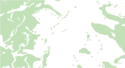
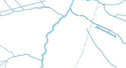
for example should be held in a blue tone, forests in a green tone, etc.
The following list shows the colours that - in
Switzerland - are reserved for their corresponding features:
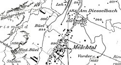
- Black: Man-made or cultural features as roads, buildings, names, boundaries, and transmission lines.
- Blue: Water or hydrographic features as lakes, rivers, canals, glaciers, and swamps.
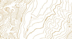
- Brown: Contour lines which show relief, but also terrain variations.
- Green / White: Landscape cover.
- Red: Important roads.
- Yellow: Secondary roads.
 Green for forests and trees (© swisstopo) Green for forests and trees (© swisstopo) |
 Blue for hydrographic features (© swisstopo) Blue for hydrographic features (© swisstopo) |
 Brown for contour lines (© swisstopo) Brown for contour lines (© swisstopo) |
 Black for man-made or cultural features (© swisstopo) Black for man-made or cultural features (© swisstopo) |
Have a look at the two examples below. The first one did not choose the feature colours according to their nature colours. Since for example the settlement areas are coloured in green they seem to be forest areas and so on. The second example did choose the right colours for each feature and it therefore became readable.
Example of a map with arbitrary colours (Institute of Cartography)Example of a map with well chosen colours (Institute of Cartography)