1.4.1. Levels of Interactivity
The map cube model
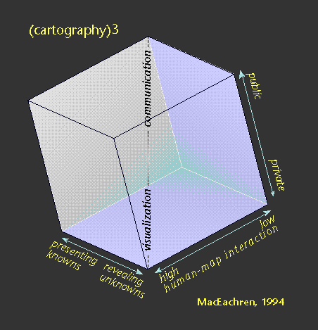
In the field of geo-visualisation, (MacEachren 1994) has presented a conceptual model (the map cube or (cartography)3 model) for categorising different types of
maps along three dimensions. In describing the model he says:
"The fundamental idea is that
map use can be conceptualized as a three-dimensional space. This space is
defined by three continua: (1) from map use that is private (where an
individual generates a map for his or her own needs) to public (where
previously prepared maps are made available to a wider audience); (2) map
use that is directed toward revealing unknowns (where the user may begin
with only the general goal of looking for something "interesting") versus
presenting knowns (where the user is attempting to access particular spatial
information); and (3) map use that has high human-map interaction (where the
user can manipulate the map(s) in substantive ways - such as effecting a
change in a particular map being viewed, quickly switching among many
available maps, superimposing maps, merging maps) versus low interaction
(where the user has limited ability to change the presentation)." (MacEachren 1994, p. 6-7)
 (MacEachren 1994)
In LBS the model has particular relevance when we think about the goals of interactivity. Highly interactive maps allow the user to pose questions about their surroundings. In maps with low interaction information is updated automatically in response changes in the user's context. We can place different types of LBS application in the model accordingly.
| High Interaction | Low Interaction | |||
|---|---|---|---|---|
| Revealing Unknowns | Presenting Knowns | Revealing Unknowns | Presenting Knowns | |
| Private Thinking | Social Navigation, exploring where others have been | Searching and browsing through points of interest or web-based data | Following a journey with an in-car navigation system | Orientation using topographic information, for example contours |
| Public Communication | Exploring distributions of phenomena, for example wildlife sightings | Browsing public service information, for example bus stops with links to timetables | Receiving 'Pushed' information as a user moves through an area | Following a guided tour, for example about architecture |
Update: 26.1.2012 (eLML) - Contact - Print (PDF) - © CartouCHe 2004-2007 (Creative Commons)
- layout based on YAML![]()